A Surveying or Spatial Science Technician collects, records and evaluates spatial information and prepares databases, maps, charts and plans in support of Surveyors, Cartographers or Other Spatial Scientists.
Occupation description
A Surveying or Spatial Science Technician collects, records and evaluates spatial information and prepares databases, maps, charts and plans in support of Surveyors, Cartographers or Other Spatial Scientists.
Alternative Title:
- GIS Technician
Occupations considered suitable under this ANZSCO code:
- Surveying Technician
- Aerial Survey Technician
- Photogrammetrist
Occupations not considered suitable under this ANZSCO code:
- Architectural, Building and Surveying Technicians nec
- Other Spatial Scientist
- Cartographer
- Building and Engineering Technicians nec
These occupations are classified elsewhere in ANZSCO or are not at the required skill level.
Surveying or Spatial Science Technician is a VETASSESS Group C occupation
This occupation requires a qualification assessed as comparable to the educational level of an Australian Qualifications Framework (AQF) Diploma or higher.
Applicants can fulfil the assessment criteria for this occupation in four different ways.
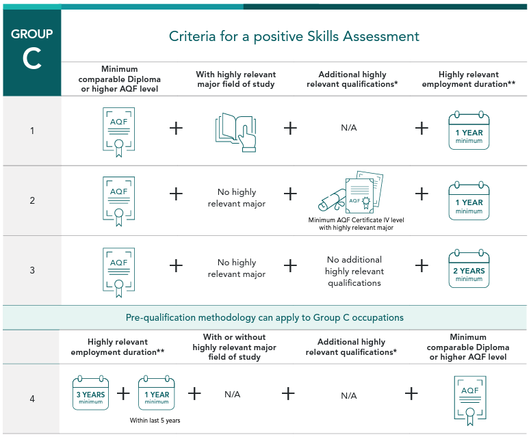
* Additional qualifications in a highly relevant field of study include those comparable to the following levels:
- AQF Diploma
- AQF Advanced Diploma
- AQF Associate Degree or
- AQF Graduate Diploma
** Highly relevant paid employment duration (20 hours or more per week)
- 1-3 minimum years of employment highly relevant to the nominated occupation, completed at an appropriate skill level in the five years before the date of application for a Skills Assessment.
- minimum 4 years of relevant employment required – three years of relevant employment (can be outside the last 5-year period) in addition to at least one year of highly relevant employment within the last five years before applying.
*If employment is prior to the completion of the qualification at the required level, an applicant must have at least one year of highly relevant employment at appropriate skill level within the last five years. The remaining three years of pre-qualifying period may be within the last ten years.
A positive assessment of both qualification level and employment duration is required for a positive Skills Assessment outcome.
Qualification and Employment Criteria
Employment
Highly relevant tasks include, but are not limited to:
- Collecting, recording and evaluating spatial information and preparing databases, maps, charts and plans in support of Surveyors, Cartographers or Other Spatial Scientists.
- Collecting data using surveying instruments and photogrammetric equipment.
- Performing routine computations and plotting preliminary data.
Additional tasks may include:
- Setting up scientific equipment and calibrating precision instruments, and diagnosing and correcting faults in equipment.
- Collecting and analysing source maps, survey data, photographs, computer records and other information.
- Using land and geographical information data bases.
Employment information
Surveying or Spatial Science Technicians are primarily involved in the collation and evaluation of geospatial information in a variety of formats (such as databases, maps and charts) to support the work of senior spatial science, cartography and surveying professionals. Applicants employed in roles suitable for assessment under this occupation may be engaged in a wide variety of employment contexts, including supporting the use of geospatial or surveying data assets and equipment. Services may be for a range of public and private entities, such as local councils, property developers, utility companies and research bodies.
As this is a technician-level occupation, employment positions where an applicant is primarily engaged in leading the development and delivery of geospatial systems, software or services would not be considered suitable under this occupation.
Similarly, roles where employment involves overseeing surveying activities rather than primarily performing technical duties and analysis is classified elsewhere in ANZSCO and would also not be deemed highly relevant to this occupation.
Supporting material for assessment
When applying for a Skills Assessment, please ensure you submit sufficient evidence supporting your proof of identity, qualification and employment claims. A full list of the documents required can be found on the VETASSESS website under Eligibility Criteria.
Get Support
Help with a Skills Assessment
Skills Assessment Support (SAS) services are for migration agents, legal practitioners and prospective applicants who are yet to submit their Skills Assessment application to VETASSESS.
Help with an urgent application
For general and professional occupations, priority processing can be used to fast-track urgent applications
How to apply
If you're a professional choosing to migrate to Australia, chances are you're likely to be assessed by us. We assess 360 different professional occupations, assessing your skills, experience and qualifications.
Find
Find the VETASSESS occupation that most closely fits your skills and experience.
Match
Match your skills and experience to your chosen occupation.
Prepare
Get ready to apply by preparing all the information and documents you need.
Apply
Apply online when you’re ready. If you’re still unsure, skills assessment support is available when you need it.